US State Maps with Counties 
|
| Map of Hawaii |  |
|
Hawaii State Map
The Map of Hawaii is accompanied by a separate county map, with the names of all counties in the "Aloha State". The Hawaiian Islands and county map, that has 5 counties, provide the location and the names of all the regions and districts in the State. The following motto is an interesting piece of information if you are travelling, going on vacation or simply learning about the State and its counties: "The life of the land is perpetuated in righteousness" The Hawaiian Islands and county map provides an outline of its jurisdiction, which covers 10,932 sq. miles. Test your skills and knowledge with our State Maps Quiz Game. | 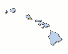
|
|
|
Facts on the Hawaiian Islands
Fast, fun facts about the Hawaiian Islands: | Map of Hawaii Facts |  | Fact 1: The Capital of the State is Honolulu which is the Largest City | | Fact 2: The Area covers 10,932 square miles | | Fact 3: 1959 was the year of statehood | | Fact 4: Hawaii is the 43rd biggest state in the USA | | Fact 5: The Number of Counties in the Islands - 5 |
| 
| Where is Hawaii? | The State of Hawaii is the only state that is made up of Islands. The Islands are located in Central Pacific Ocean in an archipelago to the western side of the United States. |
|
Map of Hawaii with Counties
The following facts and information provide maps of Hawaii with counties, together with a helpful list of Hawaii counties. The power of a county arises from state law and these vary according to each state. In America a county was among the first units of local government established in the 13 Colonies that would eventually become the United States of America. Find the location and names of all the counties in the Islands. | Map of Hawaii with Counties | | Hawaiian Islands County Map | List of Hawaii Counties | 
| Hawaii
Honolulu
Kalawao
Kauai
Maui County |
Map of Hawaii - List of Counties: Homework Help for Kids
The list of counties in the state are provided for kids and homework help and detailed in alphabetical order as follows: List of Counties | Hawaii, Honolulu, Kalawao, Kauai, Maui |
State Borders
The Maps of the state and the County provides the name of all of the counties in the state. The Government of the United States is based on the concept of federalism, meaning self-governing units. Power is shared between the National Government and State Governments, such as Hawaii, and defined by the Constitution of the United States of America. State Borders, or State lines, define geographic boundaries between each state, but being islands, this does not apply to the Map of Hawaii. |
|
Map of Hawaii and Counties | |
Map of Hawaii and County Map
|
|


