US State Maps with Counties 
|
| Map of Maine |  |
|
Maine State Map
The Map of Maine is accompanied by a separate county map, with the names of all counties in the "Pine Tree State". The Maine State Map and county map, that has 16 counties, provide the location and the names of all the regions and districts in the State. The following motto, reflects the spirit of the state, an interesting piece of information if you are travelling, going on vacation or simply learning about the State and its counties: "I guide" The maps provide an outline of its jurisdiction, which covers 35,387 sq. miles. Test your recognition skills and knowledge with our State Maps Quiz Game. | 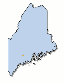
|
|
|
Map of Maine - State Borders
The outline of the state and the County Maps provide the names of all of the counties in the state. The Government of the United States is based on the concept of federalism, meaning self-governing units. Power is shared between the National Government and State Governments, such as Maine, and defined by the Constitution of the United States of America. The State Borders, or State lines of Maine, define geographic boundaries between each state. Map of Maine with Counties
The following facts and information provide a map of Maine with counties, together with a helpful list of Maine counties. The power of a county arises from state law and these vary according to each state. In America a county was among the first units of local government established in the 13 Colonies that would eventually become the United States of America. Find the location and names of all the Maine counties. | Map of Maine with Counties | | Maine County Map | List of Maine Counties | 
| Androscoggin
Aroostook
Cumberland
Franklin
Hancock
Kennebec
Knox
Lincoln
Oxford
Penobscot
Piscataquis
Sagadahoc
Somerset
Waldo
Washington
York County |
List of Counties - Homework Help for Kids
The list of counties in the state are provided for kids and homework help and detailed in alphabetical order as follows: List of Counties | Androscoggin, Aroostook, Cumberland, Franklin, Hancock, Kennebec, Knox, Lincoln, Oxford, Penobscot, Piscataquis, Sagadahoc, Somerset, Waldo, Washington, York. |
|
|
Map of Maine and Counties | List of Counties | | "I guide" State motto | | State and county maps | | State Maps, outline and State counties | | Maps and county map with names of counties | | Interesting facts, information and & pictures | | Official Nickname "Pine Tree State" | | Maps, facts and information for schools, homework, kids and children |
| |
Map of Maine and County Map
|
|


