US State Maps with Counties

50 US State Maps
 

American Symbols

United States Map

50 State Maps


Theodore Roosevelt


JFK - John Kennedy


American symbols

Map of North Carolina

Seal and Nickname

North Carolina State Map
The Map of North Carolina State is accompanied by a separate county map, with the names of all counties in the "Tar Heel State". The North Carolina State Map and county map, that has 100 counties, provide the location and the names of all the regions and districts in the State. The following motto, reflects the spirit of the state, an interesting piece of information if you are travelling, going on vacation or simply learning about the State and its counties:

"To be, rather than to seem"

The Map of North Carolina and county map provides an outline of its jurisdiction, which covers 53,821 sq. miles. Test your recognition skills and knowledge with our State Maps Quiz Game.

Map of North Carolina


Facts on the Map of North Carolina
Fast, fun facts about the Map of North Carolina:

Map of North Carolina Facts
Fact 1: The Capital of the State is Raleigh
Fact 2: The Largest City is Charlotte
Fact 3: The Area covers 53,821 square miles
Fact 4: North Carolina is the 28th biggest state in the USA
Fact 5: The Number of Counties - 100
Fact 6: The Bordering States are Georgia, South Carolina, Tennessee, Virginia)

Map showing location of North Carolina in USA

Where is North Carolina?

The State of North Carolina is located the Southeast United States bordering on the Atlantic Ocean.


Map of North Carolina with Counties
The following facts and information provide a map of North Carolina with counties, together with a helpful list of North Carolina counties. The power of a county arises from state law and these vary according to each state. In America a county was among the first units of local government established in the 13 Colonies that would eventually become the United States of America. Find the location and names of all the North Carolina counties.

Map of North Carolina with Counties
North Carolina County MapList of North Carolina Counties

North Carolina County Map

Alamance
Alexander
Alleghany
Anson
Ashe
Avery
Beaufort
Bertie
Bladen
Brunswick
Buncombe
Burke
Cabarrus
Caldwell
Camden
Carteret
Caswell
Catawba
Chatham
Cherokee
Chowan
Clay
 
Cleveland
Columbus
Craven
Cumberland
Currituck
Dare
Davidson
Davie
Duplin
Durham
Edgecombe
Forsyth
Franklin
Gaston
Gates
Graham
Granville
Greene
Guilford County
Halifax
Harnett
Haywood
Henderson
Hertford
Hoke
Hyde
 
Iredell
Jackson
Johnston
Jones
Lee
Lenoir
Lincoln
Macon
Madison
Martin
McDowell
Mecklenburg
Mitchell
Montgomery
Moore
Nash
New Hanover
Northampton
Onslow
Orange County
Pamlico
Pasquotank
Pender
Perquimans
Person County
Pitt County  
 
Polk
Randolph
Richmond
Robeson
Rockingham
Rowan
Rutherford
Sampson
Scotland
Stanly
Stokes
Surry
Swain
Transylvania
Tyrrell
Union
Vance
Wake
Warren
Washington
Watauga
Wayne
Wilkes
Wilson
Yadkin
Yancey County


Map of North Carolina - List of Counties: Homework Help for Kids
The list of counties in the state are provided for kids and homework help and detailed in alphabetical order as follows:

List of Counties

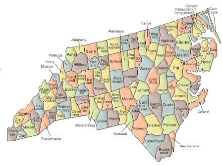
Alamance, Alexander, Alleghany, Anson, Ashe, Avery, Beaufort, Bertie, Bladen, Brunswick, Buncombe, Burke, Cabarrus, Caldwell, Camden, Carteret, Caswell, Catawba, Chatham, Cherokee, Chowan, Clay, Cleveland, Columbus, Craven, Cumberland, Currituck, Dare, Davidson, Davie, Duplin, Durham, Edgecombe, Forsyth, Franklin, Gaston, Gates, Graham, Granville, Greene, Guilford, Halifax, Harnett, Haywood, Henderson, Hertford, Hoke, Hyde, Iredell, Jackson, Johnston, Jones, Lee, Lenoir, Lincoln, Macon, Madison, Martin, McDowell, Mecklenburg, Mitchell, Montgomery, Moore, Nash, New Hanover, Northampton, Onslow, Orange, Pamlico, Pasquotank, Pender, Perquimans, Person, Pitt, Polk, Randolph, Richmond, Robeson, Rockingham, Rowan, Rutherford, Sampson, Scotland, Stanly, Stokes, Surry, Swain, Transylvania, Tyrrell, Union, Vance, Wake, Warren, Washington, Watauga, Wayne, Wilkes, Wilson, Yadkin, Yancey.

Map of North Carolina - State Borders
The Map of North Carolina provides an outline of the state and the North Carolina County Map provides the name of all of the counties in the state. The Government of the United States is based on the concept of federalism, meaning self-governing units. Power is shared between the National Government and State Governments, such as North Carolina, and defined by the Constitution of the United States of America. The State Borders, or State lines of North Carolina, define geographic boundaries between each state.


Map of North Carolina and Counties

Map of North Carolina &State map outline and county map
"To be rather than to seem" North Carolina motto
Map of North Carolina - State and county maps
Map of North Carolina outline with counties
Map of North Carolina map with names of counties
Interesting facts & picture of Map of North Carolina
Official Nickname "Tar Heel State"
Map of North Carolina for schools, kids and children


Map of North Carolina and County Map

US - American- North Carolina State Map -State - Maps - County - Counties -North Carolina State Map  State - Map - Maps - County - Counties - Outline - List - Names - Facts - Info - Information - Kids - Children - Regions - Large - America - United States - Districts - Map of North Carolina - Geography - US - USA - Kids - Children - Constitution - North Carolina - North Carolina State Map

© June 2015 Siteseen Ltd.

Cookie PolicyBy Linda Alchin Privacy Statement