US State Maps with Counties

50 US State Maps
 

American Symbols

United States Map

50 State Maps


Theodore Roosevelt


American symbols

Map of Washington

Seal and Nickname

Washington State Map
The Map of Washington is accompanied by a separate county map, with the names of all counties in the "Evergreen State". The Washington State Map and county map, that has 39 counties, provide the location and the names of all the regions and districts in the State. The spirit of the state is reflected in the Washington state motto, an interesting piece of information if you are travelling, going on vacation or simply learning about the State and its counties:

"By and by"

The Map of Washington and county map provides an outline of its jurisdiction, which covers 71,303 sq. miles. Test your recognition skills and knowledge with our State Maps Quiz Game.

Map of Washington


Facts on the Map of Washington
Fast, fun facts about the "Evergreen State":

"Evergreen State" Facts
Fact 1: The Capital is Olympia

Fact 2: The Largest City is Seattle

Fact 3: The Area covers 71,303 square miles
Fact 4: It is the 18th biggest state in the USA
Fact 5: The Number of Counties - 39
Fact 6: The Bordering States are Idaho, Oregon

Map showing location of Washington in USA

Where is Washington?

The State of Washington is located in the Pacific Northwest region of the United States.


Map of Washington with Counties
The following facts and information provide a map of Washington with counties, together with a helpful list of Washington counties. The power of a county arises from state law and these vary according to each state. In America a county was among the first units of local government established in the 13 Colonies that would eventually become the United States of America. Find the location and names of all the Washington counties.

Map of Washington with Counties
Washington County MapList of Washington Counties

Washington County Map

Adams
Asotin
Benton
Chelan
Clallam
Clark
Columbia
Cowlitz
Douglas
Ferry
Franklin
Garfield
Grant
Grays Harbor
Island
Jefferson
King
Kitsap
Kittitas
 
Klickitat
Lewis
Lincoln
Mason
Okanogan
Pacific County
Pend Oreille County
Pierce
San Juan
Skagit
Skamania
Snohomish
Spokane
 
Stevens
Thurston
Wahkiakum
Walla Walla
Whatcom
Whitman
Yakima County

List of Counties - Homework Help for Kids
The list of counties in the state are provided for kids and homework help and detailed in alphabetical order as follows:

List of Counties

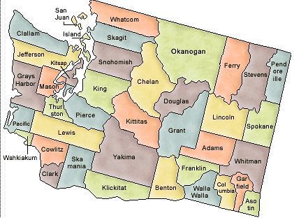
Adams, Asotin, Benton, Chelan, Clallam, Clark, Columbia, Cowlitz, Douglas, Ferry, Franklin, Garfield, Grant, Grays Harbor, Island, Jefferson, King, Kitsap, Kittitas, Klickitat, Lewis, Lincoln, Mason, Okanogan, Pacific, Pend Oreille, Pierce, San Juan, Skagit, Skamania, Snohomish, Spokane, Stevens, Thurston, Wahkiakum, Walla Walla, Whatcom, Whitman, Yakima.

Map of Washington - State Borders
The Map of Washington provides an outline of the state and the Washington County Map provides the name of all of the counties in the state. The Government of the United States is based on the concept of federalism, meaning self-governing units. Power is shared between the National Government and State Governments, such as Washington, and defined by the Constitution of the United States of America. The State Borders, or State lines of Washington, define geographic boundaries between each state.


Map of Washington and Counties

State outline and county maps
"By and by" State motto
Map of Washington - State and county maps
State outline and map of State counties
Maps and county map with names of counties
Interesting facts and Map of Washington
Official Nickname "Evergreen"
Map of Washington for schools, kids and children


Map of Washington and County Map

US - American- Washington State Map - State - Map - Maps - County - Counties - Outline - List - Names - Facts - Info - Information - Kids - Children - Regions - Large - America - United States - Districts - Geography - US - USA - Washington

© June 2015 Siteseen Ltd.

Cookie PolicyBy Linda Alchin Privacy Statement